Art at the Interface of Data and Image
Maps give a sense of objective knowledge and hence mastery of the world. In her review of artist Laura Kurgan’s book Close Up at a Distance: Mapping, Technology and Politics, Ruth Watson explores the contingency of satellite derived images, and the ‘human matters of the world’ they remain entangled in
On 26 December 2010 I was in Antarctica, staring at Mt. Erebus. Well, staring at it when I could – most of my time there seemed to be spent shovelling ice. That and an endless list of other purposeful activities, along with specialist clothing and the behaviours each of us had been inculcated to adopt, combined to create a culture bubble within which we functioned. Not that it would take much for the bubble to be violated: Antarctica does offer that often alarming experience of being a mere speck in the face of natural forces. In those conditions I gave no thought to the obvious, that there were satellites above gathering their data, with us now included. People far away from where we were, more than usually isolated from the rest of the world, would have an intimate access to information about that place; possibly more access than we had while actually there. Two years later I found some of those satellite-derived images online, knowing that our entire camp was recorded in less than one pixel of data. These kinds of images worry and fascinate me at the same time.
This data-image relationship as well as the anxiety around that interface, chimes with the work of artist/architect/academic Laura Kurgan. As a Director of the Spatial Information Design Lab at the Graduate School of Architecture, Planning and Preservation at Columbia University, South African-born Kurgan has been involved in public actions to provide information in the wake of 9/11, as well as contributing independent art works using her extensive knowledge about satellite imagery to exhibitions in Europe and the US. Both these and other works are presented and discussed in Close Up at a Distance: Mapping, Technology and Politics. Published by the renowned Zone Books, it is an unusual undertaking: a monograph on an artist’s work written by the artist. It nevertheless manages to be remarkably free of solipsism in either intention or tone, a feat achieved by concentrating less on her own work than the issues that have generated it. Her art – which Kurgan calls ‘projects’, rather than ‘a practice’ – may in effect be instances of managing the critical insights the author has about specific technologies, gained through her academic career.
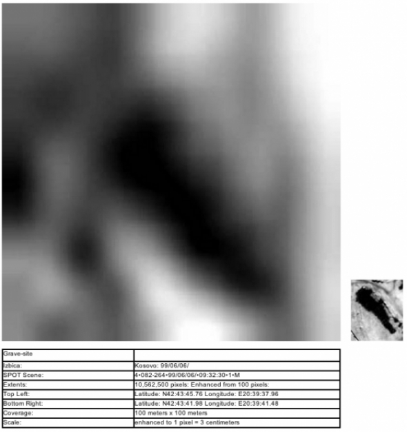
If my Antarctic experience is increasingly ubiquitous, how much more disjunctive can the tension between technologically derived acts of observation and being observed become? Quite a lot, if your life is at stake: during the genocide in Bosnia, foreign countries were relentlessly focused on the events below, from the very safe distance of the satellite’s orbit. Kurgan’s work SPOT 083-264: Kosovo June 3 1999 uses imagery taken from data recorded between 22 March and 14 June 1999, by the French company SPOT (Système Probatoire d’Observation de la Terre/Satellite Pour l’Observation de la Terre). In the book it’s difficult to actually see the final work, but the catalogue for Robert Silberman’s group exhibition Worldviews: Maps and Art shows a suite of panoramic photographs derived from satellite data, wall mounted at eye height around the gallery. These are interspersed with text panels matching the format of the photographs. So far, this seems simple; these are landscapes, seen from above in a tradition that the West and now other cultures have taken literally to a very high degree. But what is the nature of the seeing on display here and why the textual explanations, presented as equals to the imagery? The suite has one particularly long section of striking, aqua and cerise land-based imagery that graces the cover of the Close Up at a Distance, but is also punctuated by some smaller, blurry, near-monochromatic images that seem harder to fathom. In one case, an indistinct ovoid shape is revealed in a text panel as showing the kind of soil disturbance generated by a mass grave. This image – which is fundamentally, translated data – and the accompanying explanation underlines Kurgan’s point that we have to be careful in our interpretations, as these images rarely speak for themselves.
You’d think we are now used to this. We are drowning in big data and content is becoming less important than the method of interpretation, swiftly followed by the potential for use or misuse. As a rather odd species addicted to the generation of meaning through culturally transmissible sign systems, issues of interpretation have long been moot, but we seem to struggle endlessly with our own desire for the simple image, the simple map, the authoritative stamp of the real. Satellite-derived imagery has complicated photography’s love affair with the indexical further since what the satellite collects is data; this is later translated into an image, such as being given a ‘false’ colour to match location, heat level and more, and it is this constructed imagery that becomes surrounded by layers of discourse. Some argue the digital cannot claim indexicality as Peirce’s necessary contiguity is not based in a physical transformation. But the insistence on this aspect of the index may be its own form of fetish, worthy of Barthes’ focus upon it. Mark Dorrian uses the term ‘transcoded indexicality’ for digital translations and decries the thick layers of interpretation that cloak this kind of image.ii SPOT 083-264: Kosovo June 3 1999, however, insists upon the need for non-visual elaboration and warns us of its absence; it’s a position that, like the imagery itself, may carry its own time signature. Regarding the representation of the war in Bosnia, Lisa Parks wrote:
satellite images of mass graves in Bosnia are highly symptomatic of the U.S. position vis-à-vis the Balkans more generally – that is, distant and technologized monitoring, and its refusal to acknowledge (put into discourse) the complex political, sociohistorical, economic and cultural conditions that gave rise to recent conflicts in the former Yugoslavia.iii
Kurgan’s work however allows us to have conversations around the index, distance, the translation and the interpretation outside of these images being presented to us in fraught contexts by the military-information-entertainment complex, as evidence, or a justification for action.
Another key work in the book, Monochrome Landscapes (2004), has been well reproduced elsewhere.iv Each panel, individually titled Blue, White, Green and Yellow, were sourced from international satellite imagery sales, details of which are outlined in the book (e.g., Green was based on Ikonos 1-metre resolution data taken over Cameroon.v) Kurgan suggests this work raises ‘aesthetic and geopolitical’ questions; in Yellow, helicopters and their shadows can be seen flying over the desert in Southern Iraq at a time when some companies were not releasing satellite imagery that showed US troops in action.vi I have an aesthetic question: was it necessary to do this work as a ‘conversation’ with Ellsworth Kelly, whose painting Four Panels of 1970-71, illustrated on page 154, provided a formal model for the work? This aspect of the book reminds me of some art-based PhDs – a written thesis of great insight into the subject ‘informing’ the artwork, while the chosen artistic methodology remains unaddressed as if disconnected from any issues raised by the content. This is a pity. If abstraction can be shown to be loaded with geopolitics, this extends the project of revealing its ongoing complicity with matters of the world: abstraction has been exposed as contingent, subjective and at times, more site-specific than it often claimed to be.vii But to be revealed as fully entangled with the everyday, human matters of the world is to root it back in what it sometimes believed it had fled. This exploration remains interesting and useful, and could reinvest abstraction with the (different) political urgencies that drove the historical avant-gardes (with differing results). Abstraction as generated by the data, or the subsequent process of translation itself, could prove fascinating, especially in its potential to reveal some of the deep, problematic issues around this form of viewing. Parks sees abstraction and emptiness as fundamental to this kind of imagery, especially in the way people are ‘buried’ from sight, whether in Antarctica, or Bosnia. Hito Steyerl has suggested that forms of disembodied viewing represent the gaze of the dead white male, ‘a worldview which lost its vitality, yet persists as an undead but powerful tool to police the world and control its own reproduction.’viii
An earlier work, from 1995, exemplifies Kurgan’s commitment to foregrounding meta-questions around the technology itself. You Are Here: Museu used a hand-held GPS to spell out each letter of the title’s last word, from a position on the roof of the Museu d’Art Contemporani de Barcelona. The date of the work is critical, as the wonky crudeness of each letter was the result of interference from the US military. At that time, capability for high resolution had been achieved technically but was not accessible to the general populace. ‘Selective availability’, as this process of controlled access was known, was only rescinded some five years later in 2000. So the work is not only an ontological statement of location, the ‘you are here’ of the title, but of the politics around attempting to achieving that. The use of ‘museu’ can also be read as a direct invitation to think about the issues that frame the work. Kurgan remarks:
This scaleless information zone constitutes not simply the representation of a pre-existing space […] but another space altogether. The possibilities of disorientation, not in the street or on the roof, but precisely in the database that promises orientation, are of an entirely different order, and GPS offers the chance to begin mapping some of these other highways as well; drift in the space of information.ix
There are few artists in a position like Kurgan to comment with authority upon the technical aspects of satellite and other technologies of data visualisation.x Keith Sonnier and Lisa Bear made a work in 1977 called Send/Receive I and II as a plea for satellite aided transmission to contribute to human interaction and communication. It would be easy to now see this as hopelessly utopian, but their insistence on two-way use by publics outside of larger institutional users remains relevant.xi Parks writes of ‘satellite witnessing as a critical practice that refuses to accept the satellite image as an omniscient view, a strategic map, a final perspective and instead appropriates its abstraction to generate further interrogation, discussion and inquiry.’xii
Mapping and privacy are two words often not found in the same sentence.xiii Today it’s hard to escape multiple forms of digital surveillance; most of us are simply hoping no individual, organisation or state is joining up too many of the available dots about us. Yet the use of the imagery, how it is gathered and interpreted, remains critical. We don’t like this: we want the map to work for us and, paradoxically, to have its accuracy linked to its putatively objective method of generation, not human interpretation or preference. Yet cartographic enterprises are necessarily speculative, based on a desire to move from a state of conjecture towards certainty. The external, vertical ‘eye’ has long been considered stable and all-seeing; here it is mobile and in a sense, blind; it has to be programmed to look. The best path through the data must still be chosen. Kurgan’s work is valuable in showing us what we can and can’t take from the satellite – set on its timed, orbital path by people with agendas to reveal and even, to conceal. We have to become more experienced in using these processes and resulting data/image interfaces appropriately, otherwise we will become its subjects. Her work is what Parks calls for – an interrogation of the imaging processes often taken for granted in making decisions about landscapes, public and private spaces, as well as issues around collecting, accessing and releasing the data into more and more public domains. Close Up at a Distance can help us navigate the all too real world of data informed representation.
Ruth Watson <r.watson AT auckland.ac.nz> is an artist, mapaholic of some duration and occasionally, art writer and curator. She has lived in Germany and Australia, and is currently a Senior Lecturer at the Elam School of Fine Arts at the University of Auckland, New Zealand. She is working on a book on heart-shaped maps of the 16th century, and her long overdue website.
Footnotes
i Kurgan can be seen speaking about her work on YouTube; Columbia GSAPP published this presentation on 23 April, 2013: http://www.youtube.com/watch?v=cJbA4HfqOzA
ii Mark Dorrian, ‘Transcoded Indexicality’, Log no. 12, Spring/Summer 2008, pp.105-115. Dorrian and Frédéric Pousin’s edited book on the aerial view is about to be released; on the history of the view of the earth from outside itself, see Denis Cosgrove, Apollo’s Eye: A Cartographic Genealogy of the Earth in the Western Imagination, Baltimore: John Hopkins University Press, 2001.
iii Lisa Parks, Cultures in Orbit: Satellites and the Televisual, Durham and London: Duke University Press, 2005, p.83. Her forthcoming book on media spaces, ‘coverage’ and their relationship to the ubiquity of surveillance practices is likely to extend and update what remains useful in Cultures in Orbit.
iv Janet Abrams and Peter Hall, Else/Where: Mapping New Cartographies of Networks and Territories, Minneapolis: University of Minnesota Design Institute, 2006. Kurgan’s work is used for the inner back and front covers as well as being reproduced inside, and on the external back cover. In each case they are cropped to very non-Kelly proportions, reminding us about the flexibility of the original data and its extensive geographic swaths.
v Kurgan, Close Up At A Distance, p.155.
vi Ibid, p.159. The area in Iraq was between Al Busayyah and An Nasiriyah and the imagery was from 30 March 2003, during the US ‘Operation Iraqi Freedom’.
vii R. E. H. Gordon, ‘Object Lessons: Thinking Gender Variance Through Minimalist Sculpture’, a paper presented at the 2013 College Art Association Conference, 14 February 2013; http://gordonhall.net/files/REH_Gordon_Object_Lessons_.pdf
viii Hito Steyerl, ‘In Free Fall: A Thought Experiment on Vertical Perspective’, e-flux journal #24, April 2011; see note 11 on page 11.
ix Kurgan, Close Up At A Distance, p. 67.
x One project in the book used real-time data flows: Global Clock (1999-2000), visualised the unbroken flow of financial transactions at the changeover of the millennium.
xi Parks also discusses another work from 1977 by American artists Kit Galloway and Sherrie Rabinowitz of two distant but connected by satellite dancers in The Satellite Arts Project, funded by some of the major key players in the satellite industry; see Parks, Cultures in Orbit, p.171. The Bear-Sonnier work is visible via Ubuweb, http://www.ubu.com/film/sonnier_send.html
xii Ibid, p. 103.
xiii Mark Monmonier, Spying With Maps: Surveillance Technologies and the Future of Privacy, University of Chicago Press, 2002, p.1.

Mute Books Orders
For Mute Books distribution contact Anagram Books
contact@anagrambooks.com
For online purchases visit anagrambooks.com

Related Content

Proud to be Flesh: A Mute Magazine Anthology of Cultural Politics after the Net