File Diagonally

The Center for Land Use Interpretation is a stalwart promoter of what you might call 'creative geography'. If you want to know how land is utilised - whether that's for theme parks or chemical plants - this is the Bureau for you. Kate Rich talks to Matthew Coolidge.
The Center for Land Use Interpretation is a strange affiliation of artist-geographers, information hobbyists, experimental bureaucrats and a network of folks dispersed across the USA. It examines the built landscape of primarily the United States, with the idea of understanding that humans are geomorphological agents transforming the physical environment to the same degree that the major forces of nature do.
Current CLUI projects include The Limits of Fun, a photo-documentary exploring the perimeters of theme parks; the Event Marker project, promoting, for example, Whale Detonation Site Marker, Oregon; a recent series of luxury motor coach tours to secret radar-testing military bases; art-deco chemical plants and unusual spiritual sites in the LA hinterlands on which hors d’oeuvres are served.
Kate Rich headed down to Culver City, LA. Among active oil wells, contaminated sites and the Sony picture studios sound stages, she found the CLUI head office in the side-building of a converted morgue. The mission statement, displayed on the wall, urges members to increase and diffuse information about how the world’s lands are apportioned, utilised and perceived.
Matthew Coolidge, geographer: We were individuals working in our own fashion and in 1994 we decided to form an organisation in order to pursue these ideas more effectively. It was up in Oakland CA where we organised and we came down to LA in ‘96. it was a more fertile environment for the kind of work we do, I suppose.
We base our methodology on other kinds of organisations — we look to organisations like, for instance, the Smithsonian Institution for institutional guidance — National Geographic of course is another major influence. Someone once called us a postmodern National Geographic.
And on the screen here is a GIS platform where we’re developing a system to serve the information on the over 1000 locations that we’ve collected. Each of these symbols represents 1 of the 9 categories we have; what we call unusual and exemplary sites. The little military symbol is military land use; this kind of portico here is a cultural site — under cultural sites we have everything from jails to land art — and then we have intriguing industrial sites and mining sites, and water sites represented by the little droplets there. Right now we’re zoomed in on central California and there are a lot of superlative sites; the biggest, the first, the whatever. But then there are other places which are highlighted because they’re, in other ways, under-noticed and under-appreciated, or actually intentionally hiding.
KR: Your mission statement mentions the desire to explore and expand the medium of the tourism purview -
MC: Currently there’s not a whole lot of people who like to go to see these sort of distressed environments. For example waste sites, the major contaminated areas. We also have a nuclear and radioactive sites category and again they are not traditionally considered tourist attractions - but they are becoming actually now. Which is sort of surprising.
KR: How do you gather your data?
MC: Well, we talk with the Department of Energy, we do field research, and then we also talk to the network of outsiders who study these places — we stand on their shoulders, largely. A lot of (‘outsider’ is a pejorative term but) outsider scientists, you know, who are pursuing things for their own interests and aren’t part of academia and wouldn’t be accepted because they often employ unconventional research methodology. We sometimes allow those people to find a venue for their work because we, as an organisation, are outside these traditional systems as well.
KR: How does the land use Museum operate? Because you do exhibits in places that are a bit off-road...
MC: We have a number of exhibit sites. Some are quite elaborate, with actual buildings to contain the exhibits, but the Land Use Museum itself is just a network of places really. In Wendover, Utah, we have perhaps our most developed site. It’s at the edge of the Bonneville salt flats, so you have the mountains of Nevada coming down and the great Salt Lake Desert. Wendover was a WW II air base — the Enola Gay was trained out there — so they practised bombing Hiroshima on Wendover before they went over to Japan. There were 20,000 people in the desert in the ’40s and now it’s this weird combination of incredible, explosive growth and decay.
We started with just an exhibit hall out there. It’s open 24 hours a day, 7 days a week inside this old abandoned air base, and now we have about 6 buildings around Wendover. It’s a base for us to conduct research from into this incredible area. There’s the Utah side — these ruins of a military era and Mormons and very poor people living in trailers — but then there’s the Nevada side, this boom town with four big casinos; and the state line runs right through town. So you have this wonderful cultural collision, with Mormonism on one side and gambling, prostitution and 24 hour liquor on the other.
But the region is really why we’re there, this 100 mile radius of diverse industrialised desert region with all kinds of crazy and startling and compelling forms of land use. It has developed into this residence programme which people can apply for, and we are able to offer some stipends to support artists and other researchers who go out there. They live in Wendover in our facilities which are on the salt flats, on the crumbling corner of town, on the edge of the de-development there.
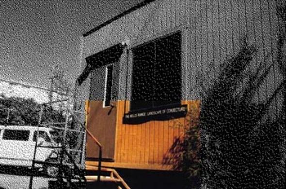
[We move next door to look at some of the fruits of CLUI research. The exhibit hall is a small parked trailer, technically a manufactured office trailer. We are looking at a photo-exhibit, Nellis Range, Landscape of Conjecture, compiled by the CLUI. The trailer has office carpet and a neat display of photographs with text panels. Venice Boulevard roars by on the other side of the walls.]
KR: This show is about Area 51?
MC: The show is actually about the Nellis range complex, 5000 square miles of Nevada ground space closed to the public since WW II. Within that space are several bases and test centres and proving grounds. Area 51 is just part of that but it’s the most secretive element of it. At least the most notoriously secretive.
KR: And you did a bus tour to coincide with the exhibition; you took a busload of people out into this military installation…
MC: We try and do this whenever possible. We also make a lot of shows with photography, but not because we like pretty pictures. We try not to get too fancy with our photographs, just use them as indexes for places. Ideally we would just go out there and look at these places directly.
KR: What was the bus tour itinerary like?
MC: Well we left from Las Vegas, from the Luxor casino. It took two days to go around the range and we had a full bus. And we met with security people and had briefers on at various points, including some Native American spiritual leaders. Right before we went on the Nevada Test Site we had the Western Shoshone leader get on the bus and give a talk about their perspective of the land, and then we had the Department of Energy come on and give us their point of view. This sort of thing went on for two days. The military wouldn’t support us with this project so they didn’t provide us with anybody although we asked them to. If you just mention Area 51 to them they just clam up and get mad. So we didn’t. Ultimately we did work with them though, and were granted access to archives that hadn’t been released, ever, archives of photos and information on the range — which I can show you here...
Nellis has become this weird virtual landscape of military training, but also this preserved landscape, this funny sort of wildlife preserve, which you often find with military sites, as well as cultural artefacts that have remained untouched out there because of the enclosure from public access. So you have this ironic combination of high-impact bombing ranges with mining cabins which supposedly still have jars still on the shelves, and native American artefacts that are really well preserved because nobody’s looted them. Area 51 itself has been around since the ’50s, when the CIA developed an R&D centre there for the development of the U2 spy plane with Lockheed. But in 1988 or so this guy came out in public and said that he worked there, back-engineering alien spacecrafts. A fellow named Bob Lazar. And that was what really stimulated the interest in Area 51 as a UFO site. Now it’s sort of evolved into this big conspiracy site in a way. A lot of ufology, it seems, is based in this notion of secretness, this cover up and the idea of the shadow government that maintains the secret; it’s very sort of X-files. But it’s not so much copying the X-files as the X-files is mining this cultural terrain: the X-files actually occasionally calls us up for information on places.
What we looked at here was really trying to understand this landscape, which means relying on the perspectives of people who have studied this from their own points of view for years. To look at how knowledge in a traditional sense, where it’s based on fact and things that you can prove, begins to trail off into the sort of knowledge that is based more on personal and even sort of mythological assumptions. And that’s what happens at Nellis. Because of the mystery about the site and its secrecy, it has become this landscape where people kind of project ideas into the space and populate it with their…world view, I guess.
This map (we had a really hard time getting it even though it’s unclassified) is a satellite view of the entire range, a recent one. And you can see, here’s the Nevada test site with all of its pockmarks from underground nuclear testing. And there’s the Tonopah test range up there, run by the Department of Energy. Every single nuclear bomb we have, the ballistics were tested out here.
There’s this thing called the Tolicha Peak electronic combat range which is visible here, with mock airfields, some at a scale of 1 to 1, that are made after actual airports in potential enemy territory. This one’s called Korean Airfield, for example; it’s a full size etching of an airport on the ground and it’s where they train pilots to attack enemy facilities. I mean, that’s one of the aspects of this range that’s really so fascinating: this has been the negative space in America, this is the Enemy terrain. This is where the American air force is trained in any incident or global situation we might find ourselves in.
Then there is all this captured Soviet stuff and, you can see over there, that sort of David Smith sculpture thing is an electronic threat, one of about 15 different Soviet electronic threats that they maintain and actually operate out on the range. They track and lock onto aircraft and send the information to a missile battery so they can shoot the plane down. So they have this sort of electronic enemyscape. It’s this interesting displacement of the world, the transposition of that landscape into this blank slate of Nevada. There’s nowhere like it in the country.
Some other sites here — and this is the latter part of the exhibit where things begin to sort of break down in terms of what’s really known and what’s speculative — this is the perimeter of the range where Area 51 is. For years the military denied the very existence of this place and there were signs outside on public land saying you couldn’t take any pictures, and the irony was, well, if according to the air force the place doesn’t exist, why should you not take pictures of it and how can that be wrong if there’s nothing there. They recently took down that sign which dealt with that dilemma, and right here this is a photograph of that sign: "it is unlawful to make any photograph, film, map, sketch, picture, graphic represent-ation of this area or equipment at or flying over this installation..."
So next to that in the exhibit is a panoramic picture of Area 51, taken from a mountain top that you can now no longer legally climb. And then there is a Russian satellite image, showing not only the Area 51 Groom Lake site, with its several mile long runway and huge facility that accommodates several thousand people, but also just below, this place called Papoose Lake. And that’s where the speculation really begins, because while on the satellite image you can see runways and things at Groom Lake, at Papoose Lake there’s nothing visible. It’s blank; it looks like a dry lake bed. Which is sort of what it is. But that’s where Bob Lazar said he worked.
He said Area 51 is just a secret R&D thing for, you know, military aircraft, but Papoose Lake is where the saucers are. And he described the base with these doors that are camouflaged to look like mountains so you can’t see them, and everything’s tucked away because they know the satellite schedule, so they can put things away to keep it from being photographed — so if you were actually trying to make a secret base disappear it would look like nothing, you know. And that’s exactly what you see when you look at this satellite image. So you have the reality and the speculation converging on a point where all you have is ground. An image of a chunk of ground, and what you see there is based on your interpretation.
So that’s where we sort of stop the exhibit, at that point, because that’s the essence, I guess, of what we’re doing, and what this landscape of conjecture is all about.
[We exit the exhibition. City buses transpose themselves ambiguously onto the surface of Venice Boulevard as I try to find my way back to Downtown.]
Kate Rich
Perceptual Arena of the American Landscape, featuring about 50 images and text from the CLUI archive, opened February 2000 at the Witte de With Centre for Contemporary Art in Rotterdam and runs until April 15.
For comprehensive information on the Centre for Land Use Interpretation, its activities and your future participation, go to www.clui.org.

Mute Books Orders
For Mute Books distribution contact Anagram Books
contact@anagrambooks.com
For online purchases visit anagrambooks.com
Proud to be Flesh: A Mute Magazine Anthology of Cultural Politics after the Net