Making an exhibition (A volumetric survey of land use in the Israeli Occupied Territories)
National outrage can be a trigger for an eloquent art show. With a catalogue entitled LAND GRAB, Israeli architects Eyal Weizman and Rafi Segal secured the cancellation of their architectural project, 'A Civilian Occupation: the Politics of Israeli Architecture', as Israel's official entry in the World Congress of Architecture (Berlin, 2002). It was banned by the same Israeli Association of United Architects who had commissioned it. Here, as one of several other participants in the Territories exhibition in which Weizman and Segal took part, Kate Rich asks how, and why, their use of aggregated data is so devastatingly effective in a contemporary art setting.
(Some points of reference. 80% of architectural work in Israel goes on in the Occupied territories. The IAUI claims flatly a position of neutrality on the occupation issue. The West Bank is described as the most intensively observed & photographed territory in the world.)
The project resurfaced, first at the Storefront for Art & Architecture in New York, and now in the TERRITORIES exhibition at Kunstwerke gallery, in the former Jewish Quarter of Berlin Mitte. Segal and Weizman's project is expanded at Kunstwerke into a 5-floor show, with about 20 other artists and groups. It displays their empirical research: work derived from collecting, analysing and synthesising information from photographs, film, legal and civic documents; travelling to settlements, commissioning new maps & chartering planes over the West Bank for self-fly aerial photography. Weizman's thesis, ‘The Politics of Verticality’ is a focal point for the exhibition and breaks out the Israeli-Palestine conflict into 3-dimensional spatio-politics. A daring, acrobatic manoeuvre.
The effect is grand and spacious, 5 floors, giant photos, map & reading rooms, monster video projections.
The politics of PradaIt is possible to be both seduced and suspicious of the installational style which conforms to the eloquence of fine-art display, assimilating natively into the atmosphere of the gallery - spacious white walls, plinth-top video terminals – and further into the environment of glossed up shops, bars and clothing showrooms of newly Tribeca-ised Berlin Mitte.
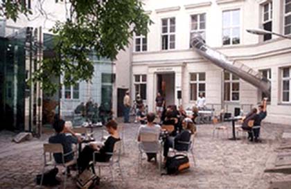 > Courtyard KunstWerke and Cafe Bravo (Florian Bolk, 1999)
Aesthetics are a decisive element in social politics. Someone I remember said that people would be more conducive to activist messages if they didn't use white helvetica on black so much.
Here the language is of architectural presentation: a clear and formally satisfying tour of landscape, design, planning and materials. Exhibits are laid out as evidence. Video loops show long-play commuter-views of the Settlement Highways (Israeli-only roads linking Tel Aviv to Ariel, Jerusalem to Hebron); or interviews with architects in their first settlement jobs.
It has the covert effect of shifting the Israel-Palestine conversation out of the popular horror-media (the testimonial volumes of Indymedia/the Independent, with their generated effects of benevolent outrage) into a way more cruel, cool & intimately placed exposition of system / technique / technology / design. It engages you directly as a cultural or design professional. Which as a visitor to Kunstwerke Gallery, its willowy garden & glassy cafe, you calculably are.
The situation in the Occupied Territories is exposed along a number of formal axes. Predominant is the Vertical: the photography - strikingly - displays the conflict from an Aerial opposed to Atrocity angle. Aerial carries an authority of both longevity and objectivity, forces the eye to look beyond the chaos of individual tragedy into the systems that feed it. The language of line, vector, surface pattern etc is non-metaphorical here: the geometrics don't so much reveal control structures as constitute and instrumentalise them.
As seen from the air, the ground war is made legible. The landscapes reveal border technologies both of a flexible and creeping nature, the systemised processes that inspire and control the movement of towns, the slow-mo coordinates of power where civic planning exposes its dark underbelly of sustained, premonitionary control.
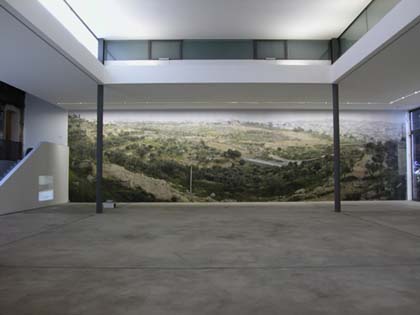
For example Landscape I, II, III: the areas around Jerusalem and Bethlehem which fill the basement room of Kunstwerke in 2-storey photographs. On first impression, a terraced view of roadways, trees & scrub, distant towns. But the photo-legend reveals a dense, embedded metastory, you pick out the Erur line (a temporary and flexible boundary that marks the current limits of the Jewish city); concealed periscopic infantry points; Jewish-only bypass roads that dive through hills to negate Palestinian town; the Separation Fence in fledgling construction. The exhibition – crucially – provides interpretational tools in the form of legends and decoders, so that photography gets refigured *as you view it* from pure visual art form to densely inhabited information space.
Readings by Colour & Hue reveal hidden geo-political data like dye tags. Regulation red roofs on Israeli dwellings ensure the architectural homogeneity of the settlements and colourchart an assault on the Palestinian worldview, encircling the hill tops overlooking their villages.
Aerial photos over the settlements of the Alfei Menashe & Har Adar expose the conflict along Arborial lines, the olive vs pine showdown - the olive trees planted by the Palestinians secure the land as 'cultivated' and thereby resistant to Israeli seizure; with counter-pine planting by Israelis [pine trees acidify the soil & ensure its barrenness], acting as place-holders for future settlement.
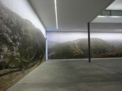
 > Milutin Labudovic: aerial image (courtesy of Peace Now): Shaked, Jenin Region, 2002
The Temporal axis is visible in Stefano Boeri's realtime, overlapping cab rides between the same start and end latitudes, screened here in sidebyside video. One journey is with an Israeli commuter, the second with a Palestinian: the Israeli journey takes 1 hour, the Palestinian 5 1/2, to cover the same [or non-same] ground.
Fluffy axis: Also shown, Amir and Sharon Balaban's Jerusalem wildlife diaries: delicate video-surveillance of animal traces in the shrinking green spaces of the Jewish metropolis - foxes slither across the lawns of the Knesset, wild deer are glimpsed through bus stop queues, rain glistens on deer noses, barbed wire and owls.
Other exhibits peer into the verticality of aerospace sovereignty, the electromagnetic sphere, radio regulation, flyovers and tunnels, water management, historical data mined from archaeological digs to "wall and tower" pioneer settlement construction.
There is a noticeable absence of Palestinian figures in these landscapes. The few humans visible through the exhibition are Jewish settlers – youthful utopian-architect-graduates, aspiring home-owners, planners, road engineers. The evidence is limited to the Israeli voice, resisting any inclination to symmetrical representation.
‘The atmosphere here is relaxing, the air is clean and dry ... a pastoral view ... a richer community life’ the settlers say (Politics of Verticality video Episode 7).
The totalising aspect of space presented provides little suggestion for resistant/hopeful intervention. (The young, soft settler architects coo, ‘we designed a public building and recommended blue roofs, to fit in with the sky, be lighter. Our client insisted on the red roofs saying that it fitted with the situation, blue to them didn't seem logical...’)
The (stated) implication: this land mass stands in for the Occupied world. The Territories merely a controlled experiment; the West Bank as showroom for border technologies and technique. It's a useful extrapolation, but what this show ultimately confirms is a specificity to case and location that works. Passage through the exhibition and its accompanying catalogue leaves an accretion of striking images: remote trailer home settlements protected by helicopter gunships; Israeli SUVs making recreational/savage sorties up sand dunes; and – most effectively – the compelling treatment of this 'news' territory in the polished discourse of architecture and design.
ReferencesIntroduction to The Politics of Verticality by Eyal Weizman, on Open Democracy
Land Grab: Israel's Settlement Policy in the West Bank: report by Eyal Weizman for B'Tselem the Israeli Information Center for Human Rights in the Occupied Territories
Territories is on at Kunstwerke in Berlin till September 7th, you can order the catalogue from info@kw-berlin.de
The Segal/Weizman catalogue Civilian Occupation has just been re-published by Verso
Kate Rich is videoengineer & roving reporter for the Bureau of Inverse Technology [BIT] whose video Bit Plane is included in the Territories exhibition. She was in Berlin to climb fences: http://bethanien.de/de/tourdefence2003.html

Mute Books Orders
For Mute Books distribution contact Anagram Books
contact@anagrambooks.com
For online purchases visit anagrambooks.com
Proud to be Flesh: A Mute Magazine Anthology of Cultural Politics after the Net