Hot-Wire Jamaica

At last, after four years of planning, the Container project has arrived
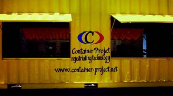
Container is a mobile media lab, launched on April 30th 2003, in Palmers Cross, a rural community in South East Clarendon, Jamaica. An initiative of media artist mervin Jarman, the container – which he describes as ‘a means of technological repatriation’ – is currently helping Palmers Cross community access new media facilities. The lab, housed in a converted 40-foot freight container, will bring workshop projects to hard-to-reach and marginalised urban and rural communities. Container’s function is to encourage disenfranchised youths and the long-term underprivileged to develop their creativity through computer use. mervin Jarman comes from Palmers Cross himself, and wanted to bring back something to the community there after more than ten years training and working – partly with the Mongrel collective – as a digital artist in London. He explains: ‘It’s about fostering the creative abilities of Jamaicans and continuing to distribute our values like we have done in the UK over the last 50 years. The UK and Europe need to feed back their technological skills into Jamaica to help sustain the culture clash that is contemporary mongrel culture.’ Far from taking a role as director, his priority has been to facilitate ownership by the community for the community. Similarly the ‘training’ methodology encourages people to pursue their own interests and ambitions, calling on the help of colleagues and professionals only if required. Jarman explains: ‘This is about each individual taking ownership of the space interpretatively, so that it becomes the best that it can be for each person. The newness of this concept is bizarre as we have always engaged in a shepherded directional learning process.’ The container is equipped with 16 networked computer workstations, running four different operating systems and a server. Members can get involved with video and audio production, office suite familiarisation, hardware and networking, web and software development. The container was donated by Jamaica Producers, and the computer hardware from Redundant Technology Initiative in the UK, SkyBuilders in the USA and ReSource in Canada. The project has been four years in the making, with most of the structural conversion, re-building of donated computers and establishment of the network done over a three month period in 2003 by a local and international team working together. An internet connection has yet to be established though, but for now the Container thrives without. If the technical side still requires some work, there is nothing lacking in the project’s ambition: ‘At the moment,’ Jarman says, ‘there is very little creative technology going on outside of the corporate landscape in Jamaica even though this is one of the loudest cultural producers of the last 40 years. We want to hot-wire Jamaica into the machine that will make the Upsetters of the future.’
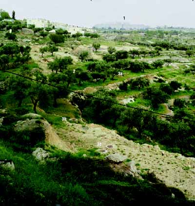
1. Har-HomaThis Jewish neighborhood was built on parts of the West Bank incorporated into the municipal boundaries of Jerusalem after the Six Day War. The land was expropriated in 1991 and construction work began in 1997, replacing a 60,000 tree pine forest. The neighborhood, about 800 meters in height, overlooks much of its surroundings and completes a ring of Israeli neighborhoods, roads and settlements that cut off Palestinian East Jerusalem from the rest of the West Bank
2. The olive orchards of the Palestinian village of Beit-SafafaThis West Bank village was incorporated into the municipal boundaries of Jerusalem following the 1967 war
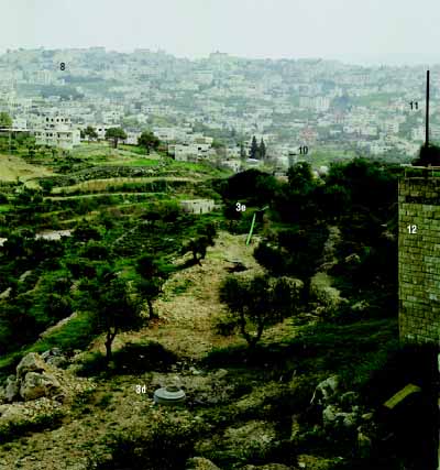
3.a,b,c,d,e. Sewage systemThe existence of a ring of sewage beyond the neighborhood boundary is an indication that further expansion of the neighborhood might take place
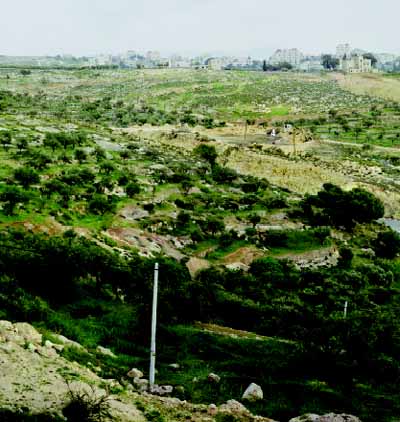
4. A tank rampant and a small infantry lookout bunker belonging to the Israeli ArmyThis position was set at the beginning of the Al-Aqsa Intifadah following frequent shooting attacks from Beit-Jala
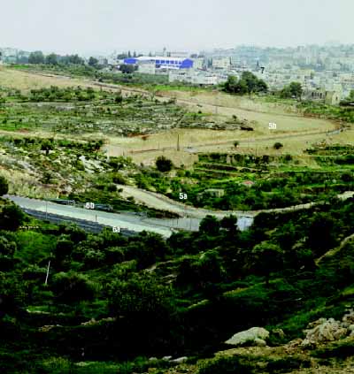
6a. An Israeli by-pass road connecting Jerusalem with the Jewish settlements to the south whilst by-passing Palestinian towns.The Israeli government is constructing a network of fast, wide security roads that by-pass Palestinian towns and connect the settlements to Israel. The by-pass roads will soon comprise a system of twenty-nine highways covering five hundred kilometers. With 150 meters of fenced-in ‘sanitary’ margins on each side, these roads are consuming much of the territory of the West Bank. They allow four hundred thousand Jews living in the West Bank to have freedom of movement, whilst enclosing about three million Palestinians into approximately 200 isolated enclaves.
Anthropologist Jeff Halper writes: ‘Roads are instruments of control and development… as mechanisms of control, they are ideal. They are permanent structures. They flow through long stretches of territory…yet they effectively claim and monopolize land by their very routes. Roads are banal. They can be made to look inoffensive and even benign and attractive – or, if need be, they can be made to look like imposing and intimidating barriers. They can be opened or closed, and used as a means to separate, unite or channel populations.’
6b. Lighting poles installed along the roadSeeking safety in vision, the by-pass roads are lit excessively. At night and from a distance they are visible as brilliant white streaks of light. The employment of light as a security measure stands in stark contrast to Palestinian techniques. Seeking safety in invisibility, Palestinians employ blackouts as a routine protection from military attacks
7. Al-A’za Refugee Camp(population:1,300)
8. Bethlehem (population:22,000)
9. HerodionThe Herodion is a fortified palace built on an artificial hill by King Herod between 22 and 15 B.C. It was both a desert retreat and part of a chain of fortresses that Herod erected in the Judean desert as protection for himself and his kingdom. During the period of the Great Revolt, the zealots built a synagogue in the existing structures. The Herodion, first explored by the American scholar Edward Robinson in 1838, forms part of a chain of archaeological sites of Jewish heritage in the West Bank. These material traces help construct a national identity rooted in the depths of the ground. They assume immense political importance as an alibi for the Israeli ‘return’ to the hills of the West Bank as the successor of ancient Israel.
10. ‘See and Seen’A prefabricated bullet proof periscopic infantry lookout positioned towards the Palestinian towns from where shooting attacks were carried out on the Jewish Neighborhood of Gilo.
11. Eruv lineThe Eruv is a Jewish, religious, temporary and flexible boundary marking the current limits of the Jewish part of the city. It is composed of metal poles with a thin wire stretched between them.
12. The oldest Jerusalem municipal by law requires square, dressed natural stone – Jerusalem Stone – for the facades and all visible walls constructed within the city limits. In the context of contemporary Jerusalem, the stone does more than fulfil an aesthetic agenda – it visually defines the geographic limits of Jerusalem and marks the extent of its holiness.
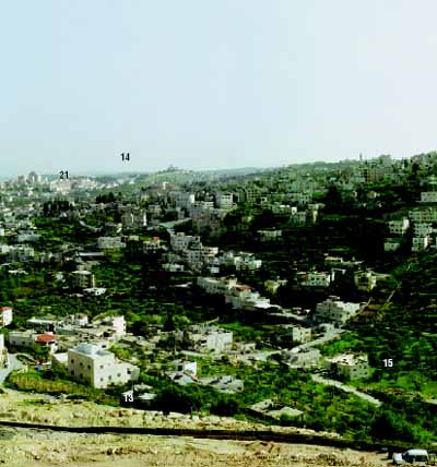
13. The Jerusalem ‘Separation Fence’
14. Hebron Mountains
15. A road block made of piled earth marks the closure of Bethlehem. Political analyst Meron Benvenisti claims that roadblocks are nothing but ‘doors with no walls,’ meant to symbolise ‘the separation’ – an absurd border crossing placed along a non-existent border
16. A Palestinian road under the Israeli bridge marks the physical separation of traffic arteries
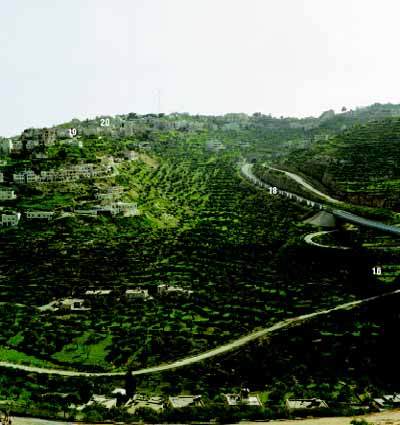
17. The Tunnel RoadThe Tunnel Road connects Jerusalem with the southern settlements of Gush Etzion and Hebron. To accomplish this without passing through Palestinian towns, it has to perform a double contortion: having stretched upwards as a bridge crossing over a Palestinian cultivated valley, it then dives into a tunnel under the Palestinian Bethlehem suburb of Bet Jallah. Meron Benvenisti writes: ‘…the person travelling on the longest bridge in the country and penetrating the earth in the longest tunnel may ignore the fact that over his head there is a whole Palestinian town … …the road managed to crash the three dimensional space into six dimensions – three Jewish and three Arab’ The volumetric separation of Jews from Palestinians is mirrored by a political separation. The legal and effective ‘border’ is stretched along a horizontal line. Palestinian limited sovereignty extends to the city overhead while Israeli sovereignty covers the road below it.
18. Bullet protection wall
19. The Arches HouseFrom this building many shooting attacks were carried out by Palestinians
20. Beit Jala
21. Bethlehem
Launched on 30 April 2003, Container is a public access multimedia arts project in Palmers Cross, Jamaica. The project encourages people to pursue their own interests, provides exposure for local talent and explores all forms of digital arts production
Information for this article came from the Container project websites [http://www.container-project.net ] & [ http://www.fraw.org.uk/jamaica ], and commissioning agency Media Arts Projects [ http://www.mediaartprojects.org.uk ]. Thanks to mervin Jarman < 4mervinATsupanet.com > and Lisa Haskel < lisaATsouthspace.org > Launched on 30 April 2003, Container is a public access multimediaarts project in Palmers Cross, Jamaica. The project encouragespeople to pursue their own interests, provides exposure for localtalent and explores all forms of digital arts production

Mute Books Orders
For Mute Books distribution contact Anagram Books
contact@anagrambooks.com
For online purchases visit anagrambooks.com
Proud to be Flesh: A Mute Magazine Anthology of Cultural Politics after the Net